For a long time, Antarctica existed on maps more as a hypothesis than as a known part of the world. European geographers imagined a vast southern landmass that would supposedly balance the continents of the Northern Hemisphere. Yet thousands of kilometres of ocean, storms, fog and sea ice lay between the imagined Terra Australis and the real continent.
Antarctica’s story is not about a single date or a single hero. It spans centuries of attempts to reach the far south, disputed sightings, dangerous expeditions, cartographic discoveries and scientific advances. At first, people tried to find the continent; later, they sought to cross it and reach the South Pole. Eventually, they developed ways to investigate even what lies beneath kilometres of ice.

1. Terra Australis: The Continent That First Existed on Maps
The idea of a great land in the far south emerged long before European navigators could reach Antarctic waters. Ancient geographical traditions suggested that the known lands should be balanced by a large continent in the Southern Hemisphere. For centuries, this hypothesis passed from one map to another, although there was no reliable information about Antarctica itself.
During the Age of Exploration, the imagined outline of Terra Australis gradually changed. Sailors reached Australia, New Zealand and islands in the Southern Ocean, but this did not mean they had discovered the Antarctic continent. Maps often combined confirmed observations with speculation, while the distant southern regions remained largely unknown.
The search for a southern continent was more than an intellectual pursuit. It reflected states’ ambitions to expand geographical knowledge, establish sea routes, find resources and increase their influence.
Did you know? Terra Australis means “Southern Land”. At first, it was a geographical hypothesis, not the precise name of a continent that had already been discovered.
2. James Cook and the Edge of the Known World
In 1772, British navigator James Cook set out on his second voyage around the world aboard Resolution and Adventure. One of the expedition’s aims was to determine whether a large continent existed in the south. Cook crossed the Antarctic Circle in January 1773 and later made several voyages into high southern latitudes.
The expedition encountered heavy fields of ice, fog and storms. Cook did not sight the Antarctic mainland, but his voyage marked a turning point. It demonstrated how difficult it was to travel farther south and greatly narrowed the room for speculation on maps. After his voyage, the idea of a southern land accessible to navigators could no longer remain as it had been.
Cook concluded that if a continent existed farther south, much of it must be covered in ice and extremely difficult to reach. His expedition did not discover Antarctica, but it paved the way for the next stage of exploration.
3. 1820: Antarctica Appears on the Horizon
The beginning of the nineteenth century proved decisive. In 1819, British captain William Smith sighted the South Shetland Islands. Several expeditions soon travelled to the region, and in 1820 sailors from different countries reported sightings of land belonging to Antarctica. The question of who first saw the continent remains a matter of historical debate: the observations were made on different dates, while weather and the navigational limitations of the time made it difficult to determine precisely what had been seen and where.
Key figures of this period include Fabian Gottlieb von Bellingshausen, Edward Bransfield and Nathaniel Palmer. A concise timeline of early expeditions is available from the Australian Antarctic Program. Their routes, records and interpretations differed, so it is more accurate to speak of a series of early sightings than to attribute the discovery unequivocally to one person. In the following decades, James Weddell, John Biscoe and James Clark Ross explored different parts of the Southern Ocean, discovering islands, coastlines and other geographical features.
Discovery did not mean that the continent immediately became well understood. Sailors saw only fragments of the coast, often from a great distance, while ice barriers prevented them from approaching many areas. Large gaps remained on maps, and the interior was almost entirely unexplored.
Did you know? The first sighting, the first confirmed sighting, the first landing on the continent and the beginning of systematic research are different events and should not be confused.
4. From the Coastline to the Interior
During the nineteenth century, expeditions described the coastline and nearby islands with increasing accuracy. James Clark Ross’s voyage of 1839–1843 was important for geography and geomagnetism: the expedition explored the southern seas, discovered new stretches of coast and described a vast ice barrier later named the Ross Ice Shelf. Meanwhile, commercial vessels and sealers and whalers accumulated practical knowledge of particular areas, although scientific mapping was not their primary purpose.
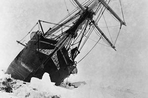
By the end of the nineteenth century, Antarctica was gradually becoming the focus of organised scientific expeditions. In 1897, the Belgian expedition aboard Belgica set out for Antarctica. The ship became trapped in the ice and had to spend the winter south of the Antarctic Circle. The crew observed the polar winter and conducted measurements in conditions few people had previously experienced at first hand.
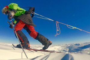
Later expeditions led by Carsten Borchgrevink, Ernest Shackleton, Robert Scott, Roald Amundsen and Douglas Mawson expanded knowledge of the coast and the interior. These journeys required not only courage but also careful planning of supplies, navigation, transport and winter survival. They produced new maps, geological samples, meteorological observations and a clearer understanding of the continent’s scale.

5. How Scientists Mapped Antarctica’s Hidden Landscape
For a long time, maps of Antarctica showed mainly its coastline, mountains visible above the ice and the routes taken by explorers. Yet ice conceals most of the continent’s bedrock surface. Knowing where the coast lies or identifying a summit rising above a glacier is not the same as understanding the structure of the continent itself.
Early information about the terrain came from sledging parties, geologists and surveyors. They measured elevations, described mountain ranges, collected rocks and mapped the features visible along their routes. Aerial photography and aviation expeditions in the twentieth century made it possible to cover much larger areas, while satellites made mapping more regular and precise.
Geophysics brought a major breakthrough. Radar instruments carried by aircraft send signals through the ice and record echoes from the boundary between the ice and the underlying bedrock. Additional information comes from seismic and gravity measurements, satellite observations, and surveys of the coast and ocean floor. By combining different methods, scientists can model a landscape that cannot be seen directly.
Researchers discovered that the bedrock beneath the ice is not a flat platform but a complex landscape of mountain systems, deep basins, valleys, canyons and depressions. Some parts of the bedrock lie below sea level. This structure matters for more than geography: it influences how ice flows towards the ocean, where meltwater accumulates and how the ice sheet may respond to warming.

Bedmap: Mapping What Cannot Be Seen
In the early twenty-first century, international scientific collaboration made it possible to bring together numerous measurements in the Bedmap series of maps. In March 2025, the British Antarctic Survey presented Bedmap3, an updated model of the terrain beneath the ice, ice thickness and related geographical features. It incorporates decades of observations from ground surveys, aircraft and other research methods.
No map can show every detail with equal certainty. Some areas have been measured extensively, while others remain less well constrained, so models must interpolate between observations. Nevertheless, the new map substantially improves our overall picture of the subglacial landscape and allows researchers to reassess earlier estimates.
One notable result concerns the location of the thickest ice. New interpretations point to an unnamed canyon in Wilkes Land, where the ice is estimated to be about 4,757 metres thick. This is not the height of a mountain or the depth of an open crevasse, but the thickness of the ice sheet above the bedrock. Read more in the British Antarctic Survey’s report on Bedmap3.
Did you know? To map the landscape beneath the ice, scientists combine measurements collected over many decades, from ground routes and sledging expeditions to aircraft, satellites and modern geophysical systems.
6. The Continent’s Highest Point: Vinson Massif
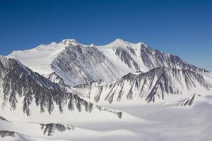
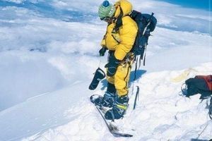
Antarctica’s highest mountain is Vinson Massif, located in the Ellsworth Mountains of West Antarctica. Its summit stands 4,892 metres above sea level according to modern geodetic measurements. The massif was named after American politician Carl Vinson, who supported funding for Antarctic research.
Vinson was mapped much later than many famous mountains on other continents. It was identified through aerial observations in the mid-twentieth century, and the first ascent was completed by an American expedition in December 1966. This was an important milestone in exploring Antarctic mountain regions, which had remained exceptionally remote and difficult to reach.
Published elevations for Vinson have changed as measurement techniques improved. Early estimates were higher than the modern figure. This does not mean that the mountain suddenly became hundreds of metres shorter: the difference reflects the accuracy of geodetic surveys, changes in methodology and more precise identification of the summit’s position.

Why the Highest Mountain Is Not the Same as the Highest Ice Surface
When we talk about Antarctica’s highest point, we usually mean the summit of Vinson Massif, a mountain measured relative to sea level. But the surface of the ice sheet also has its own rises and domes, shaped by the enormous mass of ice. This is a different kind of terrain, and its elevation should not be confused with the elevation of the bedrock beneath the ice.
Likewise, the lowest point of the bedrock is not necessarily a visible depression on the surface. It may be hidden beneath a thick glacier. That is why modern maps of Antarctica distinguish between ice-surface elevation, ice thickness and bedrock elevation.
Did you know? Vinson Massif is Antarctica’s highest mountain, but its elevation is only one of the continent’s many defining features. Mountains beneath the ice, deep basins and the shape of the bedrock are just as important to understanding Antarctica.
7. From the Race to the Pole to Permanent Research Stations
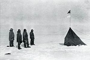
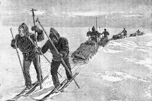
At the beginning of the twentieth century, the world’s attention was fixed on reaching the South Pole. Roald Amundsen arrived on 14 December 1911, while Robert Scott’s expedition reached it in January 1912. These events became symbols of the heroic age of polar exploration, but they were only part of a much wider effort. Expeditions were also studying geology, magnetism, meteorology, biology and the continent’s terrain.
After the Second World War, research increasingly shifted towards a permanent scientific presence. The International Geophysical Year of 1957–1958 brought scientists from different countries together in shared programmes. It demonstrated that systematic observations could reveal more than isolated short expeditions: understanding climate, the magnetic field, the atmosphere and glaciers requires long-term records.
The Antarctic Treaty was signed in Washington by 12 countries on 1 December 1959 and entered into force on 23 June 1961. It established the use of Antarctica for peaceful purposes, freedom of scientific investigation and international exchange of research results. It also provided a framework for cooperation in a region where territorial claims could otherwise become a source of conflict.
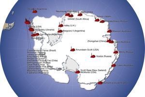
Today, many countries operate seasonal and year-round research stations in Antarctica. They enable continuous measurements of the atmosphere, ocean, ice, geomagnetic phenomena and living organisms. Antarctica has become not merely a place for records and feats, but a natural laboratory essential to understanding the planet as a whole.
8. Ukraine in Antarctica: Akademik Vernadsky Station
Ukraine’s Antarctic story has a specific location: Galindez Island in the Argentine Islands archipelago. The station now known as Akademik Vernadsky was formerly the British Faraday Station. It was transferred to Ukraine in 1996, and Ukrainian polar researchers have continued long-term observations and scientific studies there ever since.
The transfer was an important step for Ukrainian science. Ukraine gained a permanent base for Antarctic research, while Ukrainian specialists gained the opportunity to run their own programmes and contribute to international studies. The station was named after Volodymyr Vernadsky, the distinguished scientist and first president of the Ukrainian Academy of Sciences.
The station conducts meteorological, geophysical, biological and other observations. Long-term data series are particularly valuable: they reveal changes that may not be apparent during a short expedition. The work of Ukrainian polar researchers is part of a global scientific network in which measurements from different parts of the planet complement one another. The National Antarctic Scientific Center of Ukraine provides more detail about the station’s history and its transfer to Ukraine.

Did you know? The Ukrainian flag was raised over the station on 6 February 1996. The date marks the beginning of a new chapter in Ukraine’s permanent presence in Antarctica.
9. What Scientists Study in Antarctica Today
Modern Antarctic science works at several scales. Satellites measure changes in ice-surface elevation and glacier movement. Radar surveys refine our understanding of the bedrock. Ice cores preserve information about the ancient atmosphere, while oceanographic research helps explain how warmer water affects ice shelves. Biologists study organisms capable of surviving cold, limited nutrients and dramatic seasonal changes in daylight.
Antarctica is also vital to climate science. The ice sheet contains enormous stores of frozen fresh water, and its behaviour affects global sea levels. To forecast future changes, scientists need to understand not only air temperatures but also how ice interacts with the ocean and the terrain beneath it.
Another field of research focuses on subglacial lakes and water systems. Some are isolated from the outside environment by a thick layer of ice; others may form part of complex networks through which water moves beneath the ice sheet. Their existence shows that even the coldest regions on Earth are not geologically motionless or entirely devoid of liquid water.
The most important change in perspective is that researchers no longer see Antarctica as an isolated white patch on a map. It is a dynamic system in which the atmosphere, ocean, ice, bedrock and living organisms constantly interact.
10. Antarctica: A Continent Still Being Discovered
Antarctica’s history has taken it from a hypothetical Southern Land to one of the most important regions for modern science. Cook’s voyages outlined the limits of what sailing ships could achieve. Early nineteenth-century navigators sighted the continent, later expeditions mapped the coast, and twentieth-century explorers crossed the interior and reached the South Pole.
Scientists eventually learned to investigate Antarctica beneath the surface as well. Radar, satellite data and geophysical models revealed a complex world beneath the ice sheet. Modern maps, including Bedmap3, have not answered every question, but they continue to make the unknown more understandable.
Antarctica nevertheless remains a continent where every new measurement can change our understanding of Earth’s past and future. The age of discovery is not over: it continues at research stations, along routes across the ice, in laboratories and in the data scientists collect year after year.
Warmth for Your Own Journeys
Antarctic expeditions remind us how important preparation, endurance and reliable things are on the road. For everyday travel, cool evenings after a hike or memories of adventures already experienced, consider a Travel Jewelry hoodie. It is a simple way to keep a little of your love of travel close, even when the next expedition is still only a plan.
Antarctica’s story is the story of human knowledge gradually pushing back its boundaries. From the first cautious sightings to maps of the terrain beneath the ice, each generation of explorers leaves the next a more accurate picture of the world.
Amundsen and Scott: The Race to the South Pole That Changed Antarctic History
Ernest Shackleton and Endurance: The Expedition That Became a Fight for Survival
The History of Mountaineering: From the First Ascents to Speed Records
Ski Travel: The History of Ski Touring, Ski Expeditions and Winter Journeys
Gift Ideas for a Skier: Practical and Meaningful Presents for Winter Enthusiasts