Antarctica is often imagined as an endless white plain, with only a few isolated peaks rising above the ice. In reality, it is a continent of vast mountain systems, volcanoes, granite towers and formidable ice walls. Mountaineers face very different challenges in different regions, from climbing high snow-covered summits to technical granite routes that demand precise movement, rope skills and the ability to endure hours of intense cold.
Mountaineering in Antarctica developed slowly. More than a century has passed since the first ascents by polar explorers, yet many mountain regions are still rarely visited. Remoteness, unpredictable weather, complicated logistics and limited rescue options make every climb a major undertaking. At the same time, mountaineers still find peaks here that have never been climbed.

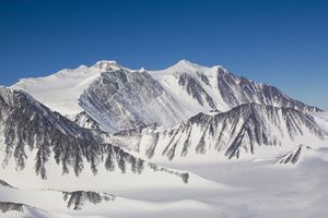
A view of the Transantarctic Mountains from a NASA research aircraft during the Antarctic IceBridge campaign.
Photo: NASA/Michael Studinger, Wikimedia Commons, public domain. File page.
Antarctica: A Continent of Mountains and Ice
Antarctica’s mountains span an immense area, and their landscapes are as varied as those of other mountain regions around the world. Some ranges form long barriers between geographical regions; others emerge from the ice sheet as isolated rocky massifs. Some peaks have rounded, snow-covered domes, while others feature sharp ridges, vertical walls and granite towers.
Altitude is not the only thing that matters to a mountaineer. A lower mountain may offer a much harder route because of steep terrain, unstable weather or the lack of a quick way out. In Antarctica, technical difficulty is compounded by logistical challenges: simply reaching a wall may require a flight, glacier travel and a self-sufficient camp.
Antarctica’s Major Mountain Systems
The Transantarctic Mountains
The Transantarctic Mountains stretch for approximately 3,000 kilometres, separating East Antarctica from West Antarctica. A broad overview of climbing history across the continent’s mountain regions can be found in the American Alpine Club’s survey of mountaineering in Antarctica. . This extensive system includes ranges and mountain groups with varied terrain: rocky massifs, high plateaus, icy slopes and places where a summit almost merges with the surface of the polar plateau.
Well-known peaks include Mount Kirkpatrick in the Queen Alexandra Range and Mount Markham. The climbing history of many parts of the Transantarctic Mountains is far less extensive than that of Vinson Massif or the mountains of Queen Maud Land. Research teams have visited some summits, although reaching a high point during scientific fieldwork does not always mean that the geographical summit was climbed.
The Ellsworth Mountains
The Ellsworth Mountains in West Antarctica include the Sentinel and Heritage ranges. Vinson Massif, the continent’s highest mountain, lies in the Sentinel Range. The region has become one of the main centres of Antarctic mountaineering, combining high-altitude routes to snowy summits with technically demanding rock and ice walls.
The early expeditions opened up not only Vinson but also a number of other major peaks, including Mounts Tyree, Shinn and Gardner. Over time, the focus shifted from reaching summits to tackling difficult routes on their walls and ridges.
The Mountains of Queen Maud Land
The mountain regions of Queen Maud Land are known for spectacular granite towers rising out of the icy landscape. Among the best-known objectives are Ulvetanna, Holtanna and the peaks of the Fenriskjeften massif. Rock climbing takes on a distinctive character here: granite walls and narrow ridges can demand long technical routes, while frost and wind make handling equipment more difficult.
These mountains attract teams seeking more than altitude: they offer difficult routes in a remote environment. Even a relatively short wall can become a major expedition because of equipment transport, narrow weather windows and the need to plan a return without expecting rapid outside assistance.
The Antarctic Peninsula and Islands
The Antarctic Peninsula and nearby islands have a different character: mountain ranges often rise straight from the sea, while glaciers descend into fjords and bays. Historically, this region has been more accessible to exploration and scientific expeditions, and many ascents have taken place here, although some early routes are incompletely documented.
This creates an intriguing problem for climbing historians: researchers may have reached a summit during mapping or geological work, yet no precise account of the ascent may have survived. Claims about “unclimbed” peaks therefore require care: the absence of a known report does not prove that nobody has ever been there.
Volcanic Peaks: Erebus and Other Volcanoes
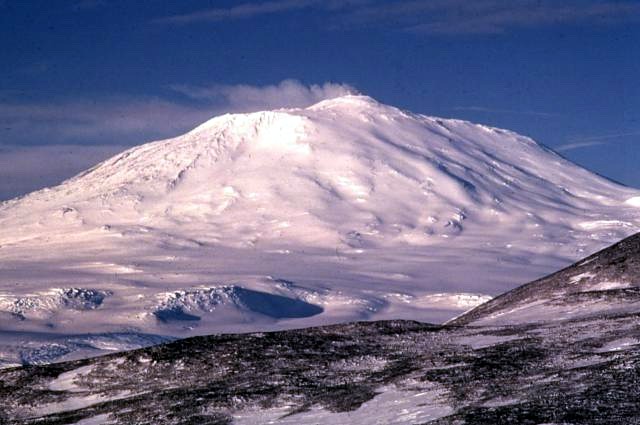
Mount Erebus on Ross Island, photographed by geologist Richard Waitt in 1972.
Photo: Richard Waitt / U.S. Geological Survey, Wikimedia Commons, public domain in the United States. File page.
Volcanoes hold a special place among Antarctica’s mountains. They are a reminder that the continent has been shaped not only by glaciers and tectonic processes but also by volcanic activity. The best-known example is Erebus on Ross Island, an active volcano that researchers have monitored for decades. A list of Antarctic volcanoes and information about their activity is available in the Smithsonian Institution’s catalogue of Antarctic volcanoes.
The first ascent of Erebus took place in March 1908 during Ernest Shackleton’s Nimrod expedition. A party of five reached the summit, including geologist Edgeworth David and the young explorer Douglas Mawson. This was more than a sporting climb: the expedition combined research into geology, volcanism and the polar environment.
Erebus became a symbol of how mountaineering and science developed side by side in Antarctica in the early twentieth century. The climbers faced cold, wind and difficult terrain while gathering data about one of the most remote volcanoes on Earth.
Another well-known volcanic feature is Deception Island, whose caldera is flooded by the sea. Its landscape combines volcanic formations, black beaches and glaciated slopes. Volcanic regions of West Antarctica and the Antarctic Peninsula are also geologically important, although not all are practical mountaineering objectives.
Volcanic activity does not mean that every such area is constantly dangerous to climb, but planning requires up-to-date information and careful assessment. Mountaineers must consider not only weather and terrain but also the specific hazards of each volcanic area.
Antarctica’s Early Climbers: From Shackleton’s Expedition to the Mid-Twentieth Century
In the early twentieth century, mountaineering in Antarctica was part of broader exploration expeditions. Teams had no access to modern air logistics, detailed weather forecasts or rapid communications. Equipment was heavy, and every journey into the mountains required careful planning of supplies and a safe return to base.
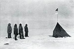
After the 1908 ascent of Erebus, mountains remained an important but not primary objective of many polar journeys. The expeditions of Roald Amundsen, Robert Falcon Scott and other explorers focused mainly on geographical and scientific goals. At the same time, their members explored nearby mountain regions, identified landmarks and documented the terrain.
After the Second World War, interest in Antarctic mountains grew alongside scientific programmes and systematic mapping. Yet several more decades passed before expeditions were organised specifically for mountaineering. A turning point came with the American expedition to the Ellsworth Mountains in 1966–1967.
Vinson Massif: The Highest Mountain on the Continent
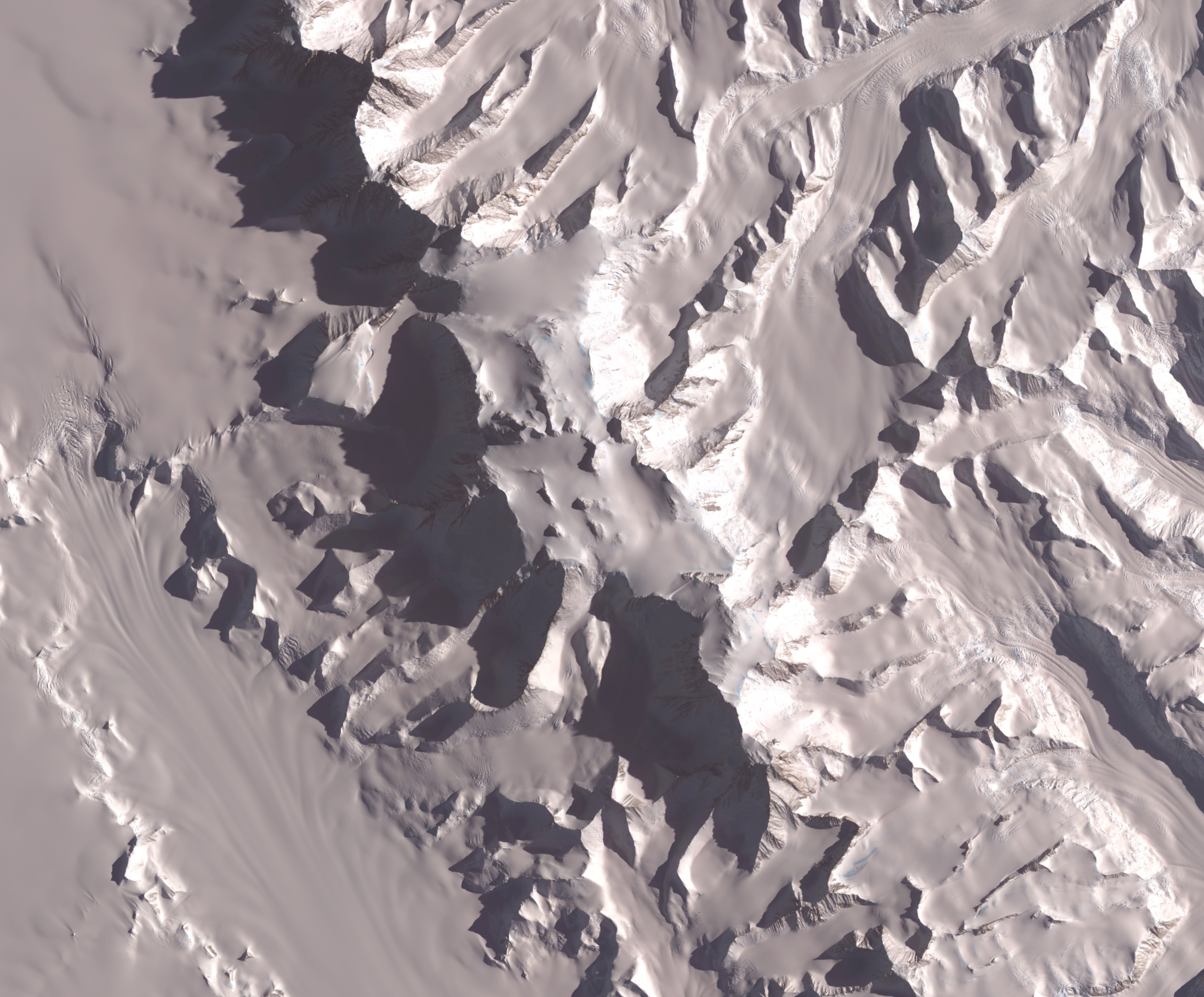
A satellite image of the central Sentinel Range, where Vinson Massif is located.
Image: ASTER aboard NASA’s Terra satellite, NASA/GSFC/MITI/ERSDAC/JAROS and the U.S./Japan ASTER Science Team, public domain in the United States. File page.
At 4,892 metres, Vinson Massif is the highest point in Antarctica. It lies in the Sentinel Range of the Ellsworth Mountains. For many climbers, it is one of the most remote peaks on the list of the Seven Summits, but its significance extends beyond the achievement of a summit.
The first ascent took place on 18 December 1966 during the American Antarctic Mountaineering Expedition led by Nicholas Clinch. The team arrived with the goal of climbing Vinson, but during 26 days in the field its members also made first ascents of six significant peaks. Besides Vinson, these included Mounts Shinn and Gardner, Mount Tyree, Long Gables and Mount Ostenso.
Today, the standard route on Vinson follows the Branscomb Glacier and is more accessible than the technical walls of other peaks in the region. However, its relative technical accessibility does not make the expedition easy: altitude, extreme cold, wind, glacier crevasses and distance from medical assistance remain serious factors.
Vinson deserves an article of its own, so here it is more useful to view it in a wider context. A new era of Antarctic mountaineering began around this massif, but some of the hardest technical challenges awaited climbers on neighbouring peaks.
Mount Tyree and Other Ellsworth Peaks: Beyond Vinson
Mount Tyree, Antarctica’s second-highest peak, shows why altitude alone is not a measure of difficulty. Its steep walls and complex terrain have long challenged climbers. In November 1989, American climber Terrence “Mugs” Stump made a solo ascent of a new route on Tyree’s west face, reportedly climbing more than 2,500 metres of difficult rock-and-ice terrain without a rope in one continuous push.
During the same period, Stump also made a solo ascent of a difficult route on the southwest face of Mount Gardner. These climbs became landmarks in Antarctic mountaineering, showing that the Ellsworth Mountains offer not only high summits but walls whose technical difficulty can rival the most serious objectives anywhere in the world.
In subsequent years, climbers opened new routes, repeated difficult lines and returned to peaks that had once seemed too remote. Climbing these mountains requires not only advanced technical skill but also sound decision-making when retreat may be as difficult as continuing.
Ulvetanna, Holtanna and the Granite Towers of Queen Maud Land

Peaks of the southern Drygalski Mountains; the sharp summit on the right is Ulvetanna.
Photo: Wilfried Bauer, Wikimedia Commons, CC BY-SA 3.0. File page and licence.
Where Vinson Massif is associated above all with altitude, Ulvetanna is synonymous with technical difficulty. Its granite summit rises above the icy landscape like a sharp tower. The first ascent was made via the northwest face in February 1994. Since then, the mountain has attracted teams seeking difficult routes on its walls and ridges.
In 2014, a British-Norwegian team completed the first ascent of Ulvetanna’s south ridge from the very base of the mountain. The route consisted of 27 pitches. The climbers’ account described not only the technical difficulties but also the challenges of managing ropes on rough granite, strong winds and summit temperatures of around minus 30°C.
Holtanna is another striking granite peak in the region. During the 2000–2001 expedition, the team changed its original plan because of rockfall danger and chose the south buttress instead. The climbers reached the summit on the night of 31 December to 1 January. The story shows that success in expedition mountaineering often begins not with rigidly following the original plan, but with recognising when to change it.
Queen Maud Land has other granite towers as well, including peaks in the Fenriskjeften massif. Their names may be less familiar to a broad audience, but these are precisely the mountains that attract climbers seeking difficult routes, remoteness and the chance to contribute to the exploration of a mountain region.
The Transantarctic Mountains: Peaks on the Frontier of Exploration
The climbing history of the Transantarctic Mountains is uneven. Some areas have been visited repeatedly, while others have remained largely the domain of scientific expeditions. In the central part of the range, including the Queen Elizabeth, Holland and Queen Alexandra ranges, the number of purely mountaineering expeditions has historically been small.
Mount Kirkpatrick is the highest point of the Queen Alexandra Range. It was discovered during Shackleton’s 1907–1909 expedition and named after one of the expedition’s supporters. Interest in the area extends beyond mountaineering: its geology helps researchers investigate the continent’s history and ancient climate conditions.
In some parts of the Transantarctic Mountains, peaks may look like small rises on a broad plateau when viewed from the south, while from the north they reveal towering walls, ice cliffs and rocky slopes. This change in perspective makes terrain harder to assess and shows why maps and photographs do not always convey the true character of a mountain landscape.
First Ascents Continue: The Gruber Mountains in 2024
The history of Antarctic mountaineering did not end with the first ascents of the highest peaks. In November 2024, climber and mountain guide Christoph Höbenreich explored the Gruber Mountains in eastern Queen Maud Land with Robert Miller, Tom Rabl and medical professional Katrin Oertel. The team climbed nine summits, seven of them first ascents. The expedition report in the American Alpine Club journal describes these first ascents and the area explored.
The area was discovered and mapped by the German Antarctic Expedition of 1939, but mountaineering ascents remained rare. In other words, an “unknown peak” does not necessarily mean a mountain about which humanity knew nothing. Often it is a well-mapped feature that climbers have yet to ascend.
The Gruber Mountains expedition is a good example of modern exploration: even with satellite imagery and detailed maps, there are still summits where the first mountaineering route has yet to be established. Such climbs require not only athletic preparation but careful logistics, self-sufficiency and planning around weather windows.
How Antarctic Mountaineering Differs from Climbing Elsewhere
Antarctica changes the usual idea of what an expedition involves. The challenge begins long before the first step on a route. A team must reach a remote area, transport equipment and fuel, plan food and shelter, and have a contingency plan in case weather causes delays.
- Cold. Low temperatures affect the handling of ropes, metal equipment, stoves and electronics.
- Wind and weather. Strong winds can halt travel, make life in tents difficult and ground aircraft.
- Glaciers and crevasses. Snow can conceal deep crevasses. Travel requires suitable equipment and experience.
- Remoteness. Rapid evacuation cannot be guaranteed. Teams must plan to be as self-sufficient as possible.
- Logistics. Flights to mountain regions depend on the weather and the availability of landing sites.
Antarctic summer, mainly from November to January, brings long daylight hours and is the main season for many mountaineering expeditions. But continuous daylight does not eliminate cold, wind or the need for proper rest. In the mountains of Queen Maud Land or on Tyree’s walls, even an experienced team must be ready to change its route or retreat.
Every Expedition Begins with Responsibility
Antarctica has a special environmental protection status. Tourist and private expeditions must comply with the Antarctic Treaty System and the national laws that apply to their organisers. Planning includes assessing environmental impact, preparing appropriately, managing waste and respecting scientific work and protected areas.
For climbers, this means leaving no rubbish, avoiding damage to rocks and historic sites, not interfering with research stations and never assuming that help will be readily available. Remoteness makes safety and self-sufficiency fundamental to every expedition.
Antarctica: A Story Still Unfolding
From the first ascent of Erebus in 1908 to recent first ascents in the Gruber Mountains, mountaineering in Antarctica has come a long way. At first, mountains were part of major exploratory journeys. Later came expeditions focused on the highest summits, followed by attempts on difficult walls, narrow ridges and remote massifs where every route demands independent judgement.
Vinson Massif remains the continent’s best-known peak, but it is only one part of a vast mountain world. Tyree and Gardner illustrate the scale of the technical challenges; Ulvetanna and Holtanna reveal the character of Queen Maud Land’s granite towers; and the Transantarctic Mountains remind us that large parts of the continent still have a limited history of mountaineering ascents.
Perhaps the defining feature of Antarctic mountaineering is this combination: legendary routes and summits already exist, yet mountains still await their first ascents. Every expedition adds to the story of a continent where nature continues to set the pace and the limits of human endeavour.
For those inspired by mountains, ice and mountaineering equipment, these images can become personal symbols of travel and climbing. The Ice pendant by Travel Jewelry combines the silhouette of an ice axe with a mountain - two forms that evoke the journey towards a summit and respect for the mountain world.
The Ice Pendant - an Ice Axe and Mountain by Travel Jewelry
Vinson Massif: Climbing Antarctica’s Highest Peak
Skiing in Antarctica: From Early Polar Expeditions to Descents from Mountain Summits
Antarctic Research Stations and Life on the Ice: How Polar Teams Live and Work
Amundsen and Scott: The Race to the South Pole That Changed Antarctic History
The History of Mountaineering: From the First Ascents to Speed Records